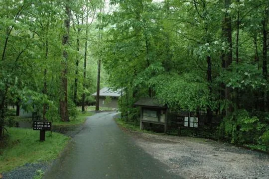
Camp Observer
Lake James State Park
1/2
Camp site features
Across 83 camp sites:
- Fire pit: all 83 sites
- Picnic table: all 83 sites
- Pets allowed: all 83 sites
- ADA accessible: 4 of 83 sites
- Longest RV: 20 ft
- Largest party: 6 people
Fees
Non-Peak Primitive Site $10.00
Non-Peak Standard Full Hookup $22.00
Non-Peak Standard with Electric Hookup $19.00
Non-Peak Standard with Water and Electric Hookups $21.00
Peak Primitive Site $10-$12
Peak Standard Full Hookup $22.00-$24.00
Peak Standard with Electric Hookup $19.00-$21.00
Peak Standard with Water and Electric Hookups $21.00-$23.00
Rules
NOTE : Gate access for campers
Gates will be locked at posted times. Campers may obtain after-hours access by request or by referencing the combination code provided on their confirmation or receipt.
All visitors not spending the night will need to be out by closing time. If you have an emergency, call 911
Due to the COVID-19 pandemic and construction projects, visitor restrictions and park status may change. Please check our website, www.ncparks.gov/lake-james-state-park/home, for more updates.
Mailing Address
Lake James State Park
PO Box 340
Nebo NC 28761
Physical Address : Paddys Creek Access
Lake James State Park
7321 NC Highway 126
Nebo NC 28761
Physical Address : Catawba River Access
Lake James State Park
2785 NC Highway 126
Nebo NC 28761
Directions
Lake James State Park is located in Burke and McDowell counties, five miles northeast of Marion on NC 126.
To get to the Paddy's Creek Area of Lake James State Park:
Traveling east on I-40: From I-40, take the Nebo/Lake James exit (exit 90) and head north. After a half mile, turn right onto Harmony Grove Road, and follow it for 2 miles to a stoplight. Proceed straight across the intersection and past Nebo Elementary School to a stop sign. Turn right onto NC 126, and follow the signs to the park entrance 4.8 miles on the right.
Traveling west on I-40: From I-40, take the Dysartsville/Lake James exit (exit 94) and head north for 0.5 mile to a stop sign. Turn left onto US 70 and follow it for 1.5 miles. Turn right onto Bridgewater Road and travel 1.2 miles. Turn left onto Benfield's Landing Road, and follow it for 2 miles to a stop sign. Turn right onto NC 126, and follow the signs to the park entrance 0.7 miles on the right.
To get to the Catawba River Area of Lake James State Park:
Traveling east on I-40: From I-40, take the Nebo/Lake James exit (exit 90) and head north. After a half mile, turn right onto Harmony Grove Road, and follow it for 2 miles to a stoplight. Proceed straight across the intersection and past Nebo Elementary School to a stop sign. Turn right onto NC 126, and follow the signs to the park entrance 2.3 miles on the left.
Traveling west on I-40: From I-40, take the Dysartsville/Lake James exit (exit 94) and head north for 0.5 miles to a stop sign. Turn left onto US 70 and follow it for 1.5 miles. Turn right onto Bridgewater Road and travel 1.2 miles. Turn left onto Benfield's Landing Road, and follow it for 2 miles to a stop sign. Turn left onto NC 126, and follow the signs to the park entrance 1.7 miles on the right.
To get to the Long Arm Boat-in Campground at Lake James State Park:
The Long Arm Boat-in Campground is only accessible by boats, not vehicles.
By power boat: Launch from the Canal Bridge Public Boat Ramp located 1.7 miles southwest of the Paddy’s Creek Area entrance on NC 126. Overnight parking is free and does not require a permit. (Overnight parking is not permitted at the Hidden Cove Public Boat Ramp.)
By canoe or kayak: Launch from the Paddy’s Creek Day-use Area, located at the end of Lake James State Park Road. Obtain a free overnight parking pass for the vehicle’s dashboard, park in the top tier of the lot, and paddle to the campsite. Campers can also launch from the Canal Bridge Public Boat Ramp located 1.7 miles southwest of the Paddy’s Creek Area entrance on NC 126.
Stay Limit
Check in from 3 PM, check out by 12 PM.
Reviews
No reviews yet
Camp Sites
Availability not checked yet
We don't have availability data yet for camp sites at .
Interested in seeing what camp sites you can reserve here? Check it now, or watch this campground so we keep checking it for you.